Tuesday, July 14, 2009
Ban Thi Po Chi
Another Karen village situated in the middle of a scenic forest. The houses in Thi Po Chi are made of natural materials such as logs and leaves within the serene natural environment. For more information, call the TAT Office in Tak Province at 05 551 4341-3.
Namtok Sepla
This medium-size waterfall is located in the area of Ban Sepla, Tambon Mae Lamung. The unique feature of the waterfall which has a width of about 10 meters and a length of about 50 meters lies in its cascading tiers with water flowing over a limestone cliff down several tiers.
Namtok Thi Lo Cho (Falling Rain Waterfall)
 Located approximately 3 kilometers from Umphang along the Umphang-Ban Palatha route, Thi Lo Cho is an 80-meter high medium-sized waterfall. Its first tier, located on a high cliff, has a stream of water that flows to the second tier which then flows down to Maenam Mae Klong. The name Thi Lo Cho is derived from the fact thath the stream, when flowing down to the rocks below, sprinkles like rain all year round. The surrounding areas of Namtok Thi Lo Cho are covered with green moss and ferns.
Namtok Thi Lo Re
 A newly-developed tourist attraction, Namtok Thi Lo Re is also situated in the Umphang Wildlife Sanctuary (declared by the UNESCO as a world heritage in 1999). Thi Lo Rae differs from other Thi Lo waterfalls in that it is the only waterfall that runs down to the rock.
To get there from Mae Sot, take a left turn to enter Highway No. 1090 (Mae Sot-Umphang) and proceed for 164 kilometers. The trip takes approximately 4-5 hours.
Namtok Thi Lo Rae is accessible by rafting along Maenam Mae Klong. Visitors can choose to travel from Umphang to the Karen village either by car or raft, then staying overnight there and continuing the journey by raft. For those who consider rafting a relaxing activity, please note that it's a 2-day rafting trip. Although it's highly recommended to travel during November-January, please call the TAT Office in Tak Province (Tel: 05 5
Tham Takhobi
 A spacious cave naturally and beautifully decorated with stalagmites and stalactites is located in Ban Mae Klong Mai, approximately 3 kilometers from Umphang. The cave itself is 3 kilometers deep with a large chamber inside the cave with a walkway connecting to Ban Mae Klong Mai.
Shrine of King Taksin the Great
 Located near the Tak TAT office, at the intersection of Charojwithithong Road and Mahatthai Bamrung Road, the Shrine houses Tak's most famous statue of King Taksin the Great. The Shrine was established in 1947 to honor King Taksin the Great who, as a designated ruler of Tak, successfully defeated the Burmese invasion of the Kingdom of Ayutthaya. During his reign, he moved the capital from Phra Nakon Si Ayutthaya to the bank side of Maenam Chao Praya and named it Krung Thonburi. That is why his statue, which is in the sitting position with a sword lying across his lap, has the following inscription at the base Phra Chao Taksin of Krung Thonburi. The site is also a center of an annual celebration during December 28 January 3.
Taksin Maharat National Park
 This national park is located at tambon Mae Tor and Pa Wor, 2 kilometers off of the km. 26 marker on the Tak-Mae Sot Highway No. 105. The Park was previously known as Krabak Yai National Park, after the name of Thailand's record-holding tree which has a height of 50 meters and a circumference of 16 meters. With an area of 37,250 acres comprised mostly of high-altitude mountains, the park features several stunning attractions including the nine-tiered Nam Tok Mae Ya Pa, a natural stone bridge and giant Kabak trees. The stone bridge is a 25-meter high stone strip that bridges two cliffs with a brook flowing below the bridge. Approximately 78.5 meters further from the cliff is a cave with beautiful stalagmites and stalactites. Bird lovers, should not miss the opportunity to see both resident and migratory birds in the park.
Talat Rim Moei
 Situated on the bank of Maenam Moei, Talad Rim Moei is a place where local products and precious stones such as jade and garnet from Myanmar are available. Tourists interested in visiting Myawadi in Myanmar (just across Maenam Moei) can take boats from this market.
Thai-Myanmar Friedship Bridge
 This bridge which connects the Asian Highway between Thailand and Myanmar, is located at Tambon Tha Sai Luad, opposite a town called Myawadi in Myanmar. The Asian Highway also runs to other regions in South Asia, the Middle East and Europe. The bridge opens daily from 8.30 a.m. until 4.30 p.m. Border passes for a fee of 20 baht for Thais and 10 baht for people from Myanmar can be obtained from either Mae Moei City or Mae Sot Municipal.
City Pillar Shrine of the Four Great Kings
 City Pillar Shrine of the Four Great Kings
This shrine is situated at Ban Pak Rong, by the Kittikachorn Bridge, south of the city. The Shrine was established to honor Thailand's four former Great Kings who were associated with Tak. These Kings called for several strategic troop assemblies in the province to fight against invading forces. In this light, the Shrine represents utmost respect for the Kings dedication to the country.
Trok Ban Chin
 Trok Ban Chin (Ban Chin Alley)
Located in Tambon Rahang, near Wat Sri Talaram, Trok Ban Chin was once the busiest place in Tak. An old port area, Trok Ban Chin used to be the center for trade and business transactions and also a distribution center for goods to and from Pak Nam Pho in Nakon Sawan Province. Today, Trok Ban Chin is not only a distant memory of the past but is also an ideal place for antique lovers and visitors interested in seeing original Thai-style teak homes.
Saturday, July 4, 2009
Lan Sang National Park
 This national park is located at Ban Lan Sang, Tambon Mae Tor, Amphoe Muang Tak, approximately 17 kilometers from the city. To get there, take Tak-Mae Sot Highway No. 105 to the west, at Km. marker 12-13 turn left into a road which leads to the National Park and proceed for 3 kilometers.
Covering an area of 104 square kilometers, Lan Sang National Park has scenic trails leading to a number of waterfalls and high granite peaks including Lan Sang, Pha Lad, lan Liang Ma, Pha Nguen, Pha Yoi and Pha Thae. The highest peak is Khao Umyorm, which is 1,065 meters above sea level. The crystal clear water of Namtok Lan Sang flows all year round and rare wildlife are frequently sited in the forest.
Thursday, July 2, 2009
Namtok Nang Khruan
 A medium-size waterfall with a stream running down the different tiers, Namtok Nang Khruan is another tourist attraction for nature lovers. It is located 12 kilometers from Phop Phra District. To get there, drive along Highway 1090, turn right at Km. 31-32 towards Highway No. 1206 (to Phop Phra).
Monday, June 29, 2009
Namtok Pha Charoen
 A spectacular 97-tiered waterfall is located between kilometers 36 and 37 on Highway 1090. To enter the site, turn left at approximately km. 36-37 markers to a dirt road off of the highway and proceed for another 700 meters to reach the site.
Friday, June 26, 2009
Namtok Mae Ka Sa
Lcated in Mae Ka Sa village, this small waterfall can be traveled to all year round. The waterfall has a stream running down from a high cliff in the midst of lush forest. A large pond situated on the upper level is perfect for swimming as it is filled with water all year.
Ban Loe Tong Ku
Lae Tong Ku is a village where residents still wear traditional clothes and continue to live a simple life. The Karen living in this village differs from other Karens as they worship a Hermit. They have their own rites which are chanted by the head of Lae tong Ku village. They also worship an image of the Lord Buddha crafted out of a sacred 400-year old tusk. To enter the village, permission from the 347th Border Patrol Police must be obtained.
Doi Hua Mot
 Doi Hua Mot is situated in Ban Umphang, just 4 kilometers from Umphang city. Limestone hills without single large tree but carpeted by blossoming shrubs and wild flowers stretching for approximately 30 kilometers, Doi Hua Mot is definitely a place for people who welcome a break from typical hills. The peak of Doi Hua Mot is ideal place to appreciate the Sea of mist and spectacular sunrise at dawn. The lookout point provides a panoramic view of Umphang and the breathtaking lush, fertile forests.
Namtok Thi Lo Su
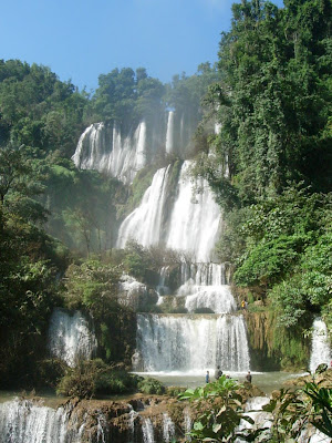 Namtok Thi Lo Su is located in the Umphang Wildlife Sanctuary, a UNESCO World Heritage site, which links with the Thung Yai Naresuan and Huay Kha Kaeng Reserves, as well as Khlong Lan and Mae Wong National Parks. Together, they form Thailand's largest wildlife haven and Southeast Asia's top virgin forest.
Thi Lo in the local language means waterfall and Su means loud, thus, Thi Lo Su means waterfall that makes a loud noise. This is due to its size and the intense flow of the stream. In Karen, "Thi Lo Su" means Black Waterfall.
The biggest and the most beautiful waterfall in Thailand, Namtok Thi Lo Su is also considered the sixth biggest waterfall in the world. The waterfall itself originates from Huai Klotho, streaming along limestone cliffs at the height of 200-300 meters down to cascading tiers which are surrounded by intact natural forests. There is a cave behind the waterfall worth exploring and several levels of pools for swimming.
To get there, visitors can either raft or drive. For those deciding to drive a 4WD vehicle, the distance is 47 kilometers from Umphang to the wildlife sanctuary office. From there, visitors have to walk along the 1.5 kilometers self-guided forest trail which provides unrivalled natural forest scenery. Please note that vehicles can possibly reach the office only during November to April. In the rainy season, Thi Lo Su is accessible only by rafting along Maenam Mae Klong. From the drop-off point, visitors have to continue on foot for approximately 4-5 hours.
Camping at the Wildlife Sanctuary Headquarters is allowed near the falls, especially during November December, when the waterfall is at its most beautiful.
Friday, May 29, 2009
Wat Mani Banphot
 This temple houses the famous Saen Thong Buddha Image, which was casted in the Chiang Saen era and can be dated back to the late 1200s.
Wednesday, May 27, 2009
Wat Sri Talaram
 Located in Trok Ban Chin, Wat Sri Talaram is not just an ordinary temple located in a peaceful area. The most unique feature of Wat Sri Talaram is its European-style architecture, reflected in its ordination hall. In addition, enshrined within the sermon hall made of carved wood is an ancient Ayuthaya-style Buddha image.
Wat Don Kaeo
 This temple houses Thailand's biggest and most beautiful marble Burmese-style Buddha image. The width of the image base is 50 inches while the height is 63 inches. The temple is situated on the Mae Sot-Mae Ramat-Tha Song Yang route at Km. 33. To get there from the main road, take a left turn and proceed for another 2 kilometers.
Travel to Tak, Thailand
Welcome to my blog,Travel to Tak. Here you will know about Tak In Thailand and how to Travel to Tak, tips for Travel to Tak and more about Travel to Tak.