 A spectacular 97-tiered waterfall is located between kilometers 36 and 37 on Highway 1090. To enter the site, turn left at approximately km. 36-37 markers to a dirt road off of the highway and proceed for another 700 meters to reach the site.
Monday, June 29, 2009
Namtok Pha Charoen
A spectacular 97-tiered waterfall is located between kilometers 36 and 37 on Highway 1090. To enter the site, turn left at approximately km. 36-37 markers to a dirt road off of the highway and proceed for another 700 meters to reach the site.
Friday, June 26, 2009
Namtok Mae Ka Sa
Lcated in Mae Ka Sa village, this small waterfall can be traveled to all year round. The waterfall has a stream running down from a high cliff in the midst of lush forest. A large pond situated on the upper level is perfect for swimming as it is filled with water all year.
Ban Loe Tong Ku
Lae Tong Ku is a village where residents still wear traditional clothes and continue to live a simple life. The Karen living in this village differs from other Karens as they worship a Hermit. They have their own rites which are chanted by the head of Lae tong Ku village. They also worship an image of the Lord Buddha crafted out of a sacred 400-year old tusk. To enter the village, permission from the 347th Border Patrol Police must be obtained.
Doi Hua Mot
 Doi Hua Mot is situated in Ban Umphang, just 4 kilometers from Umphang city. Limestone hills without single large tree but carpeted by blossoming shrubs and wild flowers stretching for approximately 30 kilometers, Doi Hua Mot is definitely a place for people who welcome a break from typical hills. The peak of Doi Hua Mot is ideal place to appreciate the Sea of mist and spectacular sunrise at dawn. The lookout point provides a panoramic view of Umphang and the breathtaking lush, fertile forests.
Namtok Thi Lo Su
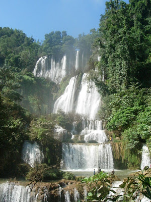 Namtok Thi Lo Su is located in the Umphang Wildlife Sanctuary, a UNESCO World Heritage site, which links with the Thung Yai Naresuan and Huay Kha Kaeng Reserves, as well as Khlong Lan and Mae Wong National Parks. Together, they form Thailand's largest wildlife haven and Southeast Asia's top virgin forest.
Thi Lo in the local language means waterfall and Su means loud, thus, Thi Lo Su means waterfall that makes a loud noise. This is due to its size and the intense flow of the stream. In Karen, "Thi Lo Su" means Black Waterfall.
The biggest and the most beautiful waterfall in Thailand, Namtok Thi Lo Su is also considered the sixth biggest waterfall in the world. The waterfall itself originates from Huai Klotho, streaming along limestone cliffs at the height of 200-300 meters down to cascading tiers which are surrounded by intact natural forests. There is a cave behind the waterfall worth exploring and several levels of pools for swimming.
To get there, visitors can either raft or drive. For those deciding to drive a 4WD vehicle, the distance is 47 kilometers from Umphang to the wildlife sanctuary office. From there, visitors have to walk along the 1.5 kilometers self-guided forest trail which provides unrivalled natural forest scenery. Please note that vehicles can possibly reach the office only during November to April. In the rainy season, Thi Lo Su is accessible only by rafting along Maenam Mae Klong. From the drop-off point, visitors have to continue on foot for approximately 4-5 hours.
Camping at the Wildlife Sanctuary Headquarters is allowed near the falls, especially during November December, when the waterfall is at its most beautiful.